Airfield Viewing Guide - RAF Marham
If you see any suspicious vehicles or activity, please report it to the guardroom on 01760 337694. Also please note that the land surrounding much of the airfield is farmland and the farmers are extremely sensitive to people abusing their hospitality and walking through crops.
General Description
RAF Marham is located South-East of Marham village, about 9 miles South-East of Kings Lynn and 6 miles West of Swaffham in Norfolk. Marham is the RAF and RN's ground attack centre, home the F-35 Lightning force.
| ICAO | Telephone | Web links |
|---|---|---|
| EGYM | 01760 337261 | RAF Marham |
| Aerial view |
| Frequencies | |
|---|---|
| Frequency | Description |
| 124.150 | Zone/LARS |
| 231.525 | Operations |
| 233.075 | Approach |
| 234.325 | PAR secondary |
| 242.200 | Air to air |
| 246.025 | Air to air |
| 277.225 | ATIS |
| 278.125 | Air to air |
| 280.275 | Operations |
| 281.150 | Tower |
| 282.250 | LARS |
| 284.000 | Operations |
| 290.300 | Air to air |
| 298.825 | PAR primary |
| 314.250 | Operations |
| 343.175 | Air to air |
| 361.750 | Air to air |
| 372.300 | Operations |
| 376.375 | Air to air |
| 377.475 | Director |
What you can expect to see
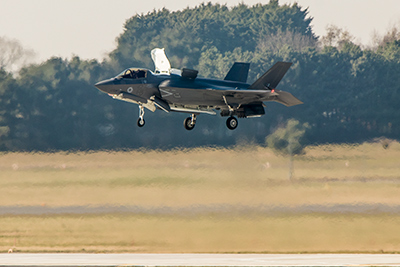
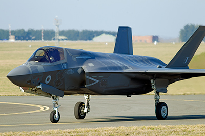
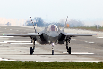
Resident F-35B Lightnings of 207 Squadron (the OCU) and 617 Squadron. Sadly, with the Tornado gone, action is even less frequent than in those days, and Lightning flying is reduced in scale. However, with the Lightning force currently building, they aren't spending all their time on simulators so you do have a good chance on any day of seeing some noisy activity. There are three vertical landing pads located in the middle of the airfield in the triangle formed by the three runways (two active ones and the 'lazy' disused one).
Visitors can be just about anything - I've seen Hawks and Tucanos come in and stay for a few hours while every man and his dog seems to use the runway here for practice approaches - Tutors, Hawks, UC-12s from Mildenhall, etc. F-15s from Lakenheath are often to be seen high up in the sky above Marham, transiting to or returning from the ranges up North, and occasionally pop in here for lunch too.
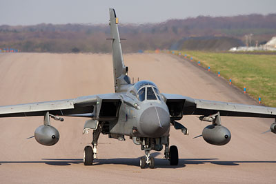
Marham has a Tornado gate guard plus a Victor and Canberra preserved within the station (by the Station Headquarters, not really visible from outside and currently up for disposal). For pictures of any of these, contact the CRO in advance. Sometimes redundant airframes are dumped out on the airfield on the loop hardstandings along the southern perimeter taxiway but this has not really been the case since the Canberra force retired.
Activity is normally limited to between 09:00 and 18:00 weekdays; on summer evenings and at weekends there can be some glider activity, but very little chance of anything else.
Viewing
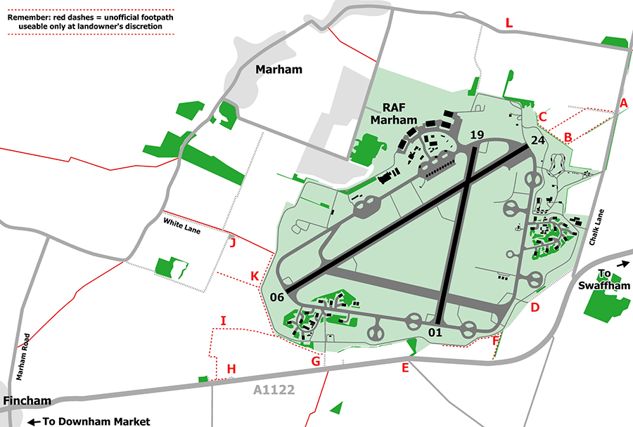
Assuming you're coming off the A47 from the East, turn off onto the A1122. It will curve left after a few miles and there'll be a turn on the right signposted 'Chalk Lane'. Take this turn. Continue for about one mile up Chalk Lane, past the crossroads controlled by traffic lights (access to the old bomb dump) and keep on going until the you see a field on your left with the approach lights in it, and a large gap in the hedge (point A). There is room for numerous cars to park off the road on both sides here and also at other spots a little further along the road, but please do not block the farmer's access, particularly to the track that runs towards the approach lights. The dip down into the field on the the west side of the road here is also becoming an issue, so don't go getting stuck!
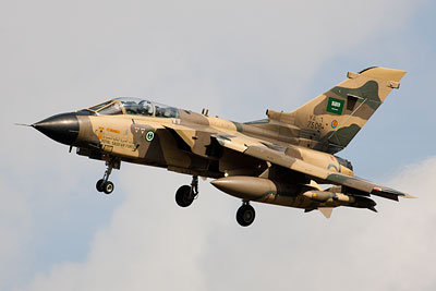
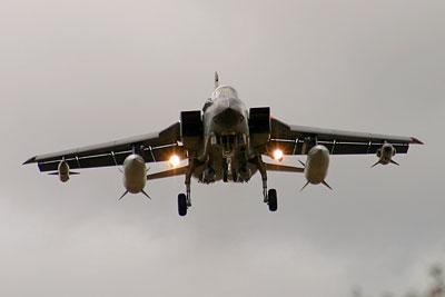
Saudi Tornado on final approach (taken from the hedge line between points A and B; author
From here you have a clear view of aircraft departing 06 (though they'll be quite higb) and good views also of anything on approach to 24 - though again, they're a bit high for good shots. So, for closer views it's time for some walking, and hope that the farmer hasn't been annoyed recently. There are two routes to get closer to runway 24, first is follow the track towards the approach lights, and then follow the lights to the hedge. Second is to follow the field edge (DO NOT walk through any crops!) to your left and turn right when you reach the hedge. Both really rely on the farmer not objecting - people have mixed results, depending on which particular farm worker they speak to and how other enthusiasts have behaved towards them. Strictly speaking the land the approach lights is on belongs to the MoD; however to get to that you are using the farmer's land, and RAF Marham would prefer that people do not hang around directly under the approach path. Therefore it is best to stick to the field edges. Anyway, assuming your luck is in, you can get much better landing shots from closer to the airfield fence (e.g. point B).
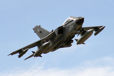
Tornado departing 06 (taken from near point B); author
There is a hedge along this fence line, and it's just high enough to make life difficult - a stepladder is of limited use as the ground is so soft for much of the year. There are occasional variations in height and a gap at point B that offer a clear view. The lie of the land within the airfield and the crash barrier gear means that clear shots of aircraft on the ground at this end can be tricky - you'll need to do some walking up and down the fence to find useful spots. Facing the runway, the sun is behind you in the early morning and moves through the day until it is right in front of you. When the sun has shifted to the other side of the approach, simply walk north along the hedge line, through the approach lights, and you'll reach point C which offers a similar gap in the hedge to point B. When runway 01/19 is in use, this corner of the field is one of the closest points you can get to the runway 19 approach, but it's still too distant for decent photos, and the runway itself isn't visible as the ground slopes away from you.
Lightning vertical landing (taken from between points D and F); author
Aircraft taxiing onto the runway can do so from both sides though most Lightnings and visitors will come from your right, with few others from your left (best viewed from point C rather than B). Lightnings are often to be found in the main hangars North of the runway, so you may see one being towed out, or a visiting aircraft parked in front of the hangars. Unfortunately that's too far away for decent photos but fine for serials on non-hazy days. Sadly the 'temporary' hangars on the flight line mean any aircraft on this line are usually hidden away.
Now, return to your car (remember to stick to the rough ground around the approach lights or the edge of the field), and drive back down Chalk Lane towards the main road once more. As you go pass the bomb dump access a field will open up on your right; when the airfield fence comes back towards the road, this is the edge of the eastern HAS complex. However, there's nothing to be seen because of numerous obstructions and double fencing.
Lightning taxiing (taken from near point D); author
So, continuing towards the main road... just before you get to the junction you'll see a lane on your right, turn in here and drive to the end (point D), taking care not to block the crash gate when you park up. From the fence here there are limited views on to the nearby taxiway. Sometimes the farmer is OK with people walking along the fence here but if they are busy in the fields this lane is in constant use by farm vehicles so you will be better off parking elsewhere. Drive back to Chalk Lane, turn right and turn right at the main road (towards Downham Market).
Lightning rolling out on runway 19 (taken from between points E and F); author
After ¾ of a mile you'll see a field opening on your right, limited (considerate) parking has been tolerated here (and the farmer opened up this field for the final days of Tornado operations) so you may be OK to park in here, as long as you keep your vehicle well off the access track and out of the field itself.
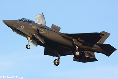
Lightning on approach (taken from point E); Richard Flagg
If not, continue onwards to the next turn on the left (White Road, point E). There is a small bit of scrub that can take a few cars at the junction end, but otherwise this road is very narrow and offers very few opportunities to park, all of them some distance away. From here you can photograph aircraft on approach to 01 and also walk - farmer permitting - towards the airfield to get to the yellow runway end fence (west of point F) to get various views of the southern taxiway (and the approach to 01). The corner here is great for head-on shots down these taxiways (on the rare occasions they are in use).
For views of aircraft on approach to 06 or departing 24, back to the car and keep driving towards Downham Market. The first small lane on your right is access to a house, ignore that, but the next lane very shortly after that is White Lane which leads to another crash gate. Room to park here (point G) is minimal - really it's at the start of the lane only, or you'll be blocking crash access. Walk up the lane and you can follow the perimeter fence along the field edge to get to the runway end - eventually! For an easier option, keep driving!
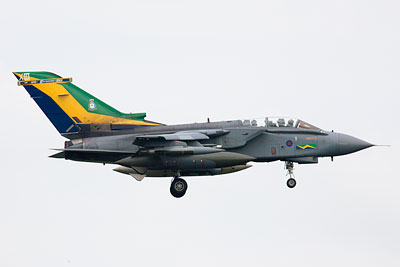
Tornado on final approach to 06 taken from point H, 600mm); author
Just before the turn for Barton Bendish you'll see a rough layby on your right; pull over here (point H), if there is any room left - for this is one of the most popular spots at Marham and the layby is now very uneven and reduced in size from previous years. There is a pretty clear view of much of the airfield from this hill, and 24 departures and 06 arrivals are both pretty easy to photograph. 24 departures tend to bank left towards you in order to avoid overflying Fincham village. If there is no room to park, there are a couple of smaller bits of rough ground on the same side of the road in either direction; alternatively, the minor road to the south offers some roadside parking opportunities.
Tornado on final approach to 06 taken from point I); author
It is possible, farmer permitting, to walk down to the approach lights from here - keep to the field edges, initially up the hill towards the mobile phone mast, then towards point I and onwards to point K if you wish. It's a fairly substantial walk and pretty muddy for much of the year. When there are any crops in these fields it may be best to avoid them and try and keep the farmer happier!
So, back to the car for one more way to reach the runway 06 end! Continue driving along towards Downham Market and you'll come into the village of Fincham. Take the first right, signposted for RAF Marham, and keep on going to a T junction. Turn right here and follow the road as it turns sharp left (there's a rough track on the right here - I don't advise it, it is very rough and when muddy becomes impassable unless you have a 4x4). Keep on going and as the trees thin out on your right you'll see a lane on the right - this is White Lane once again (the airfield cuts off a large portion of this old lane). There are gates on this lane but they are normally open; assuming this is so, you can drive along it. Be warned - it is just an unpaved lane, and cars with limited ground clearance will probably find it impossible to proceed far. Any wet weather means it can be very muddy too.
Tornado taxiing taken from point K, 500mm lens); author
Anyway, assuming your car can get up here, you'll come to an area of hardstanding (point J) and a big storage tank. Park considerately so that the farmer can still make use of the various rough tracks and you can now proceed on foot down the grassy track towards the airfield (there's a crash gate at the end of the track). A short walk south from the crash gate (e.g. to point K) will get you a head-on view down the taxiway. This is not used as much as the southern taxiways, but when it is the photo opportunities are definitely worth it! The airfield fence here is chainlink but not too tall - shorter people may need a step stool to see over but most should be OK to see over it without assistance.
A walk a little further south is great for approach photos if 06 is in use; there is also a limited view of the western HAS complex and a long lens may net a useable shot of anything parked outside the two nearest shelters, though heat haze limits your chances of that. As you progress along the fence it changes to wooden slats but the height remains pretty much the same and the ground next to the fence tends to rise up anyway, giving you enough elevation to see over it. As with the 24 end, please do not hang around directly under the approach path.
For views of anything on approach to 19, it's a long drive around to a small layby at point L, but this is some distance away from the runway and offers no clear views of the airfield.
That's it for Marham - the most popular locations are definitely points A and H, but the better photographic opportunities require both some walking and some luck with (and consideration towards) the local farmers.
Other Information
Petrol and shops available in Swaffham; Little Chef cafe with loos off the A47 near the A1122 junction (Northbound side only, if going from Marham, go down the A47, take the Swaffham turn off and keep right on the slip road to do a u-turn and go back onto the A47 northbound). There is a convenience store near the station entrance, and one a little further away on the road towards Marham village.
The RAF Police trawl around the local roads but as long as you are parked safely and aren't acting dodgy they'll normally leave you alone. Nobody on the station seems particularly bothered about spotters hanging around at the end of runway 24, unless you're directly under the approach - at other points though, because of the difficulty of getting to them, you may very well attract some attention!
RAF Lakenheath is only 20 miles away to the South; about a 30-40 minute drive - take the A1122 back to the A47, off onto the A1065 and through Swaffham and then just stay on the A1065. RAF Lakenheath will soon show up on your right after the town of Brandon.
Contributors: author, Nick Challoner, Alistair Henderson, Milscanners, Richard Flagg, David Boughen.